Datoteka:Extent of the Hansa-optimiert.jpg
Prijeđi na navigaciju
Prijeđi na pretragu

Veličina ovog prikaza: 800 × 457 piksela. Druge rezolucije: 320 × 183 piksela | 640 × 366 piksela | 1.024 × 585 piksela | 1.280 × 732 piksela | 2.560 × 1.464 piksela | 3.605 × 2.061 piksela.
Izvorna datoteka (3.605 × 2.061 piksela, veličina datoteke/fajla: 11,37 MB, MIME tip: image/jpeg)
Opis izmjene
| Opis |
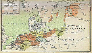
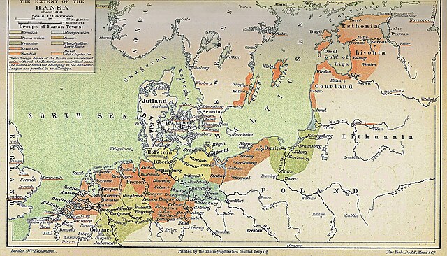
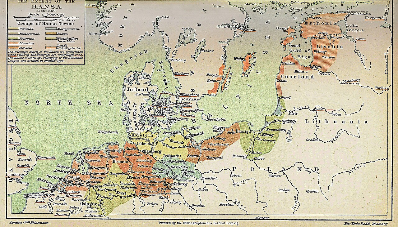
English: Map: The Extent of the Hansa about 1400 |
||||||
| Datum | / 2008 | ||||||
| Izvor | H.F. Helmolt, History of the World, Volume VII, Dodd Mead 1902. Plate between pages 28 and 29. | ||||||
| Autor | Credited as London: Wm Heinemann / Friedrich Graf | ||||||
| Dopuštenje (Ponovna upotreba ove datoteke) |
Bild:
Ova datoteka je licencirana pod Creative Commons licencom Attribution-Share Alike 3.0 Njemačka.
 |
||||||
| Ostale verzije | Extent_of_the_Hansa.jpg, Extent_of_the_Hansa.png |
Licenciranje
Bild:
This media file is in the public domain in the United States. This applies to U.S. works where the copyright has expired, often because its first publication occurred prior to January 1, 1929, and if not then due to lack of notice or renewal. See this page for further explanation.
|
 | |
 |
This image might not be in the public domain outside of the United States; this especially applies in the countries and areas that do not apply the rule of the shorter term for US works, such as Canada, Mainland China (not Hong Kong or Macao), Germany, Mexico, and Switzerland. The creator and year of publication are essential information and must be provided. See Wikipedia:Public domain and Wikipedia:Copyrights for more details.
|
Änderungen:
Ova datoteka je licencirana pod Creative Commons licencom Attribution-Share Alike 3.0 Njemačka.
- Slobodno smijete:
- dijeliti – umnožavati, raspodjeljivati i prenositi djelo
- prerađivati – prilagođavati djelo
- Pod sljedećim uslovima:
- pripisivanje – Morate pripisati odgovarajuće autorske zasluge, osigurati link ka licenci i naznačiti jesu li napravljene izmjene. To možete uraditi na bilo koji razumni način, ali ne tako da se sugerira da davalac licence odobrava Vas ili Vašu upotrebu njegovog djela.
- dijeljenje pod istim uslovima – Ako mijenjate, transformišete ili nadograđujete ovaj materijal, morate ga objaviti i distribuirati samo pod istom ili sličnom licencom poput ove.
Izvorna evidencija postavljanja
Transferred from de.wikipedia to Commons by Heubergen using CommonsHelper.
The original description page was here. All following user names refer to de.wikipedia.
- 2008-11-17 15:29 Friedrich Graf 3605×2061× (11926825 bytes) {{Information |Beschreibung = Map: The Extent of the Hansa about 1400 |Quelle = H.F. Helmolt, History of the World, Volume VII, Dodd Mead 1902. Plate between pages 28 and 29. |Urheber = Credited as London: Wm Heinemann / Friedrich Graf |Datum = 1902 / 200
Historija datoteke
Kliknite na datum/vrijeme da biste vidjeli tadašnju verziju datoteke.
| Datum/vrijeme | Minijatura | Dimenzije | Korisnik | Komentar | |
|---|---|---|---|---|---|
| aktualna | 20:49, 29 maj 2013 | | 3.605 × 2.061 (11,37 MB) | File Upload Bot (Magnus Manske) | Transfered from de.wikipedia by User:heubergen using CommonsHelper |
Upotreba datoteke
Sljedeća stranica koristi ovu datoteku:
Globalna upotreba datoteke
Ovu datoteku upotrebljavaju i sljedeći projekti:
- Upotreba na projektu ar.wikipedia.org
- Upotreba na projektu bg.wikipedia.org
- Upotreba na projektu ca.wikipedia.org
- Upotreba na projektu da.wikipedia.org
- Upotreba na projektu de.wikipedia.org
- Upotreba na projektu en.wikipedia.org
- Upotreba na projektu eo.wikipedia.org
- Upotreba na projektu es.wikipedia.org
- Upotreba na projektu et.wikipedia.org
- Upotreba na projektu fr.wikipedia.org
- Upotreba na projektu id.wikipedia.org
- Upotreba na projektu ja.wikipedia.org
- Upotreba na projektu mk.wikipedia.org
- Upotreba na projektu nds-nl.wikipedia.org
- Upotreba na projektu no.wikipedia.org
- Upotreba na projektu ru.wikipedia.org
- Upotreba na projektu sc.wikipedia.org
- Upotreba na projektu th.wikipedia.org
- Upotreba na projektu uk.wikipedia.org
- Upotreba na projektu www.wikidata.org
- Upotreba na projektu zh.wikipedia.org