Datoteka:RedArmy19Aug31Dec44.jpg
Prijeđi na navigaciju
Prijeđi na pretragu
Veličina ovog prikaza: 788 × 600 piksela. Druge rezolucije: 315 × 240 piksela | 631 × 480 piksela | 1.009 × 768 piksela | 1.256 × 956 piksela.
Izvorna datoteka (1.256 × 956 piksela, veličina datoteke/fajla: 531 kB, MIME tip: image/jpeg)
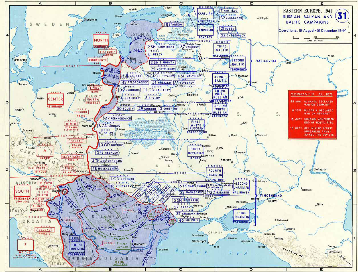
Taken from the campaign series, made public by the US-Army under www.dean.usma.edu The picture is public domain. It shows the situation of the Easter Front from 13. Aug. '44 until 31. Dec. '44
- Source: dean.usma.edu archive copy at the Wayback Machine
From website:
- In 1938 the predecessors of what is today The Department of History at the United States Military Academy began developing a series of campaign atlases to aid in teaching cadets a course entitled, "History of the Military Art." Since then, the Department has produced over six atlases and more than one thousand maps, encompassing not only America’s wars but global conflicts as well.
- In keeping abreast with today's technology, the Department of History is providing these maps on the internet as part of the department's outreach program. The maps were created by the United States Military Academy’s Department of History and are the digital versions from the atlases printed by the United States Defense Printing Agency. We gratefully acknowledge the accomplishments of the department's former cartographer, Mr. Edward J. Krasnoborski, along with the works of our present cartographer, Mr. Frank Martini.
- Please be aware that these maps are large in file size and may require substantial download times.
Ova je slika djelo pripadnika ili zaposlenika Oružanih snaga SAD-a načinjena u vrijeme obavljanja službe. Kao djelo američke savezne vlade, slika je u javnom vlasništvu.
|
 |

|
This map image could be re-created using vector graphics as an SVG file. This has several advantages; see Commons:Media for cleanup for more information. If an SVG form of this image is available, please upload it and afterwards replace this template with
{{vector version available|new image name}}.
It is recommended to name the SVG file “RedArmy19Aug31Dec44.svg”—then the template Vector version available (or Vva) does not need the new image name parameter. |


Historija datoteke
Kliknite na datum/vrijeme da biste vidjeli tadašnju verziju datoteke.
| Datum/vrijeme | Minijatura | Dimenzije | Korisnik | Komentar | |
|---|---|---|---|---|---|
| aktualna | 20:47, 12 januar 2015 | | 1.256 × 956 (531 kB) | Spiridon Ion Cepleanu | Borders of years 1940-1944 (rectified some little mistakes) |
| 12:52, 22 april 2007 |  | 1.256 × 956 (203 kB) | Nasiruddin | Taken from the campaign series, made public by the US-Army under www.dean.usma.edu The picture is public domain. It shows the situation of the Easter Front from 13. Aug. '44 until 31. Dec. '44 *Source: [http://www.dean.usma.edu/history/web03/atlases/grea |
Upotreba datoteke
Sljedeća stranica koristi ovu datoteku:
Globalna upotreba datoteke
Ovu datoteku upotrebljavaju i sljedeći projekti:
- Upotreba na projektu ar.wikipedia.org
- Upotreba na projektu ca.wikipedia.org
- Upotreba na projektu cs.wikipedia.org
- Upotreba na projektu de.wikipedia.org
- Upotreba na projektu el.wikipedia.org
- Upotreba na projektu en.wikipedia.org
- Upotreba na projektu es.wikipedia.org
- Upotreba na projektu et.wikipedia.org
- Upotreba na projektu fr.wikipedia.org
- Upotreba na projektu he.wikipedia.org
- Upotreba na projektu id.wikipedia.org
- Upotreba na projektu it.wikipedia.org
- Upotreba na projektu ja.wikipedia.org
- Upotreba na projektu nl.wikipedia.org
- Upotreba na projektu pl.wikipedia.org
- Upotreba na projektu pnb.wikipedia.org
- Upotreba na projektu ro.wikipedia.org
- Upotreba na projektu ru.wikipedia.org
- Upotreba na projektu sr.wikipedia.org